Weekly Volcanic Activity Report 22-28 December 2021
Accordin to the Smithsonian's Global Volcanism Program and the US Geological Survey's Volcano Hazards Program new activitywas reported for 5 volcanoes
Ambae
The Vanuatu Meteorology and Geo-Hazards Department (VMGD) raised the Alert Level for Ambae to 2 (on a scale of 0-5) on 27 December, noting confirmation of a cone that has built up in Lake Voui and increasing activity. A vent in the lake had been emitting steam-and-gas emissions and ejecting wet tephra above the lake’s surface since 5 December. The public was warned to stay outside of the Danger Zone defined as a 2-km radius around the active vents in Lake Voui and away from drainages during heavy rains.
Source: Vanuatu Meteorology and Geo-Hazards Department (VMGD)
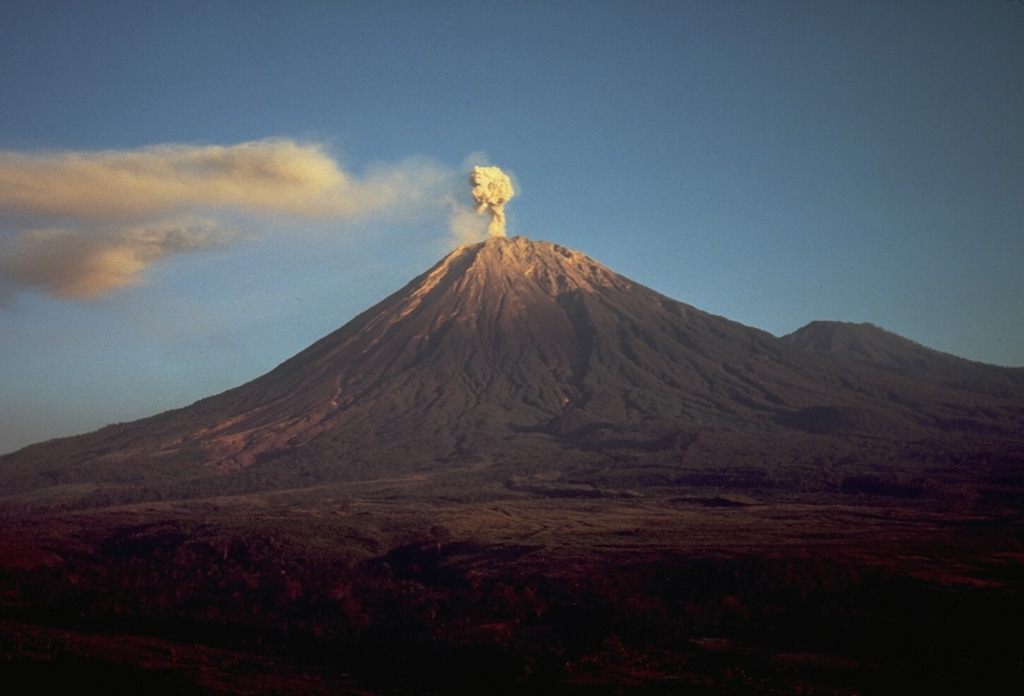
Hunga Tonga-Hunga Ha'apai
The eruption at Hunga Tonga-Hunga Ha'apai that began on 20 December continued through 28 December. According to the Wellington VAAC continuous gas-and-steam plumes with diffuse ash rose 6.1-12.2 km (20,000-40,000 ft) a.s.l. and drifted NE and NNE during 22-23 December, based on pilot observations, satellite images, information from the Tonga Meteorological Office, and weather models. On 22 December Tonga Navy crew sailing near the island recorded Surtseyan explosions ejecting tephra 350 m high. The video confirmed that the vent was in the same area as the 2014 activity. According to a news article plumes of sulfur dioxide spread NNE over the Ha'apai, Vava'u, and Niuatoutapu island groups with the highest concentrations affecting the ‘Otumu‘omu‘a islands on 23 December.
Plumes became intermittent by 24 December rising to 10.4 km (34,000 ft) a.s.l. and occasionally as high as 12.2 km. Tonga Geological Services warned the public to stay outside of a 5 km radius of the vents. According to Tonga’s Lead Geologist, satellite images from 25 December showed that the island had grown 300-600 m on the E side, and ash was falling within a 10 km radius. During 25-28 December the gas-and-steam plume rose 9.1-12.2 km (30,000-40,000 ft) a.s.l. and drifted N and NE; the lower part of the plume contained ash and rose as high as 3 km (10,000 ft) a.s.l. Ashfall was confined to the vicinity of the volcano. Tonga Geological Services reported that during 27-28 December clouds of gas and steam drifted E across the ‘Otu Mu’omu’a Islands of Ha’apai at altitudes of 1-18 km (3,300-59,000 ft) a.s.l.; they warned residents to protect water reservoirs because rain may be acidic or contain traces of ash, though the plumes were predominantly drifting at high levels. One flight to Tonga was canceled on 28 December, for the second time since the eruption started.
Sources: Wellington Volcanic Ash Advisory Center (VAAC), Tonga Meteorological Services, Government of Tonga, Tonga Geological Services, Government of Tonga, Kaniva Tonga, Kaniva Tonga, Matangi Tonga Online, Matangi Tonga Online, Matangi Tonga Online, Matangi Tonga Online, Matangi Tonga Online, Matangi Tonga Online
Krysuvik-Trolladyngja
Icelandic Meteorological Office (IMO) reported that the earthquake swarm at the Krýsuvík-Trölladyngja volcanic system was ongoing at least through 26 December. The swarm began at 1800 on 21 December in an area 2-4 km NE of Geldingadalir. Around 3,000 daily earthquakes recorded by the seismic network were mostly located near Fagradalsfjall volcano at depths of 5-8 km, though some were located near the town of Grindavík and lake Kleifarvatn. The swarm was episodic with periods of intense activity. Three earthquakes over M 4 were recorded near Grindavík on 24 December; the largest was a M 4.8. Deformation during 20-26 December was clear in InSAR data, and similar to the deformation observed at the end of February as the dike intrusion was starting near Fagradalsfjall. The seismicity and deformation indicated that magma was moving at depth, likely along the same dyke system that fed the previous eruption at Geldingadalir. The Aviation Color Code remained at Orange.
Source: Icelandic Meteorological Office (IMO)
Piton de la Fournaise
OVPF reported that an eruption at Piton de la Fournaise began at 0105 on 22 December on the S flank, SE of Piton Kala Pélé and SW of Château Fort. Four fissures opened and produced lava fountains, with the lowest point of the eruption at an elevation of 2,000 m. By the evening, the eruption was focused at 2,030 m elevation where a cone was forming around the vent. The lava effusion rate based on satellite data was an estimated 4-7 meters per second, with peak rates of 22 meters per second, during 22-23 December. By 0930 on 23 December the cone was 10 m high and low lava fountains intermittently rose above the crater rim. Lava flowed from an opening at the base of the cone, though a lava tube was beginning to form; lava had descended 2.2 km SSE from the main vent. During 24-25 December lava traveled from the base of the cone hundreds of meters through a tube before it emerged and advanced in a single channel; the front of the flow had advanced slowly, only traveling an additional 300 m by 25 December. During 25-26 December the lava tube broke open and lava was again visible emerging from the base of the cone. The flow rate was between 2 and 27 meters per second, averaging 5 meters per second. A second vent at the base of the cone was visible in the morning of 27 December and lava was again flowing through a tube and then emerging downstream. Lava fountaining continued with material occasionally ejected less than 15 m above the cone during 27-28 December. The effusion rate was an estimated 2-8 meters per second, based on satellite data. The end of the lava flow had not notably advanced since the day before.
Source: Observatoire Volcanologique du Piton de la Fournaise (OVPF)
Semeru
PVMBG reported that the eruption at Semeru continued during 21-28 December. Crater incandescence was visible overnight during 22-23 December and four block avalanches traveled 800 m down the Kobokan drainage on the SE flank. Two pyroclastic flows descended the Kobokan drainage a maximum distance of 5 km. Dense gray plumes rose 500 m above the summit during 23-24 December and three avalanches of material traveled 500 m down the SE flank. At 1706 on 25 December and at 0902 on 28 December ash plumes rose 300 m above the summit and drifted SW and N, respectively. The Alert Level remained at 3 (on a scale of 1-4). The public was warned to stay at least 500 m away from Kobokan drainages within 17 km of the summit, and other drainages originating on Semeru including the Bang, Kembar, and Sat, due to lahar, avalanche, and pyroclastic flow hazards.
Source: Pusat Vulkanologi dan Mitigasi Bencana Geologi (PVMBG, also known as CVGHM)
Post a Comment